Want to learn more about North Carolina? Download our FREE 29-page Guide of “101 Things to do in North Carolina” when you sign up for our Email Newsletter!
The Deep Creek Trail in Bryson City has one of our favorite waterfall chasing features . . . multiple waterfalls on a single hike! Similar to the Dupont State Forest’s 3 Sisters, Deep Creek Trail has three very different waterfalls all accessible within an interconnected hiking loop. The Three Waterfalls Loop is a total of 2.4 miles (3.86km) with a modest 580’ (177m) gain in elevation on what is rated a moderate hike. As with most waterfall hikes it’s best to get an early start before it gets crowded but in the parking lot and on the trails.
The Deep Creek Trail trailhead is easy accessible by heading due north from downtown Bryson City and bearing right on Water Street. The road turns into Toot Hollow Road then, at about the 1.4 mile mark, you’ll take a left onto West Deep Creek Road which will dead end at the large trailhead parking lot. There is an excellent old barn to your right and a place to rent tubes along the way. Once you arrive there’s a map that shows different options available, including the 4.6 mile (7.4m) Indian Creek Loop if you’re feeling a bit more ambitious.
As you head up the main path you’ll see, and hear, the whitewater of Deep Creek to your right and see plenty of interesting rock formations to your left. The trail is very wide and equally flat with slight occasional elevation lifts and drops. It is an easy and pleasant walk with an abundance of natural beauty all around you to enjoy.
Tom Branch Falls
The Tom Branch Falls is less than a half-mile from the trailhead, situated across the Deep Creek. As you approach the falls you’ll see a few sections you can choose from to view the falls. First is a set of wooden benches followed by a flat section set between two large trees. Next are a set of three wooden benches with wide stairs that go down to the river’s edge. Each of these three vantage points offer unique views of the falls.
The Tom Branch Falls is 80’ (24.4m) in height and consists of roughly nine sections as it descends down the rock levels. Technically it is considered a cascade falls as the water descends a series of rock steps until it spills into the Deep Creek below. Over time the water has cleared itself a path as evidenced by the lush overgrowth on either side. Take some time to soak in the sounds and sights that only a waterfall can provide.
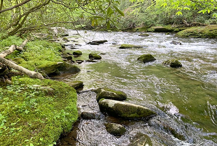
Back on Deep Creek Trail
As you proceed back on Deep Creek Trail you’ll get a steady stream (pun intended) of active whitewater and moss covered banks on either side of Deep Creek. There are several trees with exposed roots towering over rocky stones smoothed from centuries of water exposure. About 7 minutes from the Tom Branch Falls you’ll take a bridge over the creek in one of the calmer stretches of water.
Some of the cliffs around the bridge are beautiful with thin tall trees reaching skyward for any sunlight they can find. On the other side of the bridge, to your left, is a great section to stop and explore. There is a long bank of shale-like moss covered rock followed by a huge boulder that leads to a great series of whitewater rapids. The higher portion of the bank has a fascinating series of exposed tree roots that seem to go on forever. In the distance is yet another series of rapids equally as impressive.
While the trail stays wide and flat it does begin to get steeper as the creek becomes more obscured by the trees and plant-life high on the bank. There are a few openings where you can get a good look at the whitewater below. There is also a cluster of large boulders to your right that is worth a look.
Soon you’ll reach a crossroads with option to go right to the Indian Creek Trail or straight across a bridge to continue the 3 Waterfalls loop. Before making that decision take some time to explore the area around the bridge. To you left you can walk down to a few spots along the creek’s bank. Thee you will find a number of large and smaller boulders that, along with some dips on the creek’s floor, create some great whitewater. A look back towards the bridge and you see a cascade that comes from the Indian Creek Falls.
Indian Creek Falls
Back to the crossroads . . . follow the sign to Indian Creek Falls by walking up the hill. You’ll see a sign on your left followed by stairs that bring you to the main platform for viewing the falls. In total this cascade is an impressive 45’ (13.7m) long though the main section you see from the platform is almost a 25’ (7.6m) square. Because the falls are so close it feels, and certainly sounds, much larger.
After spending a few minutes of this magnificent cascade there is a path to the left of the platform that allows you to work your way over onto an island that sits near the base of the falls. This different vantage point really shows how wide the falls are and how the water has carved a distinct path out of the surrounding wilderness. It’s also fascinating to see how relatively calm the water becomes as it levels out before hitting the next slope just above the bridge.
When you get back to the main path continue up the hill where you’ll see even more great views of the falls through the trees. In a few minutes you’ll get to a small wooden bridge. From the bridge you get a birds-eye view of the water way that feeds the falls below. As we worked our way back down the main path we noticed an opening to the right that gave way to a steep, but manageable, path right alongside the top of the falls. What happened next was the highlight of our entire trip!
The path brought us right to the edge of the falls and the sound was like constant thunder. We were able to see a higher part of the falls not quite visible from the original platform. We also got a straight-on view of the top of the main falls as well as a unique view looking almost straight down.
You can venture all the way down to the base of the falls but be careful to not disrupt the surrounding fauna. As you descend the views reveal some of the intricacies of the falls from the underlying rock formations to the sections that shift the flow of the cascade. After spending a good half hour exploring we began the climb back up to the main path.
Deep Creek Horse Trail
At the bottom of the Indian Creek Trail turn right to cross over the bridge and start winding your way up the wide path. The water will be to your left and remain a companion until you reach yet another bridge. Before the bridge there is a great section of whitewater rapids spilling over an assortment of different sized rocks and boulders. Over the bridge is the beginning of the horse trail so keep an eye both ahead and on the ground.
This is the longest stretch of hiking on the loop. You’ll cross over a makeshift bridge and start to head on a more steady incline. There is much less water but still plenty to enjoy between the towering forests, leafy bushes and mossy hillsides.
While much of this portion of the hike is uphill there are some flat areas and even occasional decline. You’ll encounter a series of wide switchbacks a midst valley forests and exposed tree roots. About halfway the path starts to turn downhill and the forests become slightly less dense and take on more character and color.
Juney Whank Falls
At the sign for Juney Whank Falls you descend down some steps to a path that leads to a bridge with the falls on both sides. In total the falls covers 80’ (24m) in length though most of it occurs on a slight slope on the other side of the bridge. You can stand on the bridge to get the best look at the falls which is only a few feet in front of you or stand on one of the boulders to the right for great picture opportunities.
There is a path on the right side of the falls that allows you to ascend to the top of the falls. While it isn’t as dramatic as other similar falls it’s always interesting to see things from different perspectives.
As you move your way to the other side of the bridge you see different aspects of the falls. In particular you get a better view of the striations in the rock that cause the water to change directions and intensity. On the other side you get a better view of the falls, the bridge and the cascades that continue down the other side of the mountain.
Juney Whank Falls Loop
Once you reach the top of the steps the hike back to the parking lot is a short .3 mile (.48km). The views are beautiful, especially in the morning sun. There is one last mini-falls just before the parking lot that rounds out the hike very nicely. Be sure to keep a look out for that barn on the way back!
Deep Creek Trail Final Thoughts
It is so cool that a hike like this, much less the waterfalls, are located so close to Bryson City. You see some wonderful examples of unspoiled nature on the Great Smoky Mountain Railroad trip but nothing can beat walking right in the middle of nature.
Do you have a favorite hike or waterfall chasing destination? We’d love to hear about it!
Please follow and like us:
1 thought on “Deep Creek Trail in Bryson City, NC”


1-1); waitfor delay ‘0:0:15’ —